3D GIS
There is a big push in the GIS world to go 3D. But this is being met with quite the resistance. The reasons I hear are that organizations don't have time, resources, the right programs, money, and the biggest reason, why?
The conversion process can take a long time, but the results are incredible.
The first time I was tasked with converting something to 3D, it was daunting. Nobody had done it before. There wasn't any documentation online about how to do so. Tech support was no help.
First, I started with LiDar points, and pulled out trees and buildings. I spent 2 weeks learning how to change the roof types and directions, the tree heights and canopy spreads. I felt like I was building a video game (does anyone remember Half Life?).
I finally got it to work. And I was proud of figuring it all out.
A random engineer came to my desk to ask for a map. He saw my screen and asked "What is that?" I told him all about it. How long it took and how difficult it was. And that I had finally figured it all out. He responded, "Who in the world would want that? Nobody will want that. What a waste of time." He threw his hands in the air and walked away before I could respond.
Awesome.
That afternoon was a public meeting for the project. I was given a 3D bridge design to add into this 3D scene for the public meeting 30 minutes prior. The bridge was added in, and the designers said they didn't realize it was so big.

The public meeting did not go as planned, with lots of comments from excited residents over the size of this thing in their backyards. But it was a success. It brought real-world context to a design. It started the conversation. And people loved to see where they lived, and yes that is what their house looks like, and yes they do have those trees and that shed in their yards.

So where can you start?
Show exactly how that proposed design will impact it's surrounding area.

Show exactly where those underground utilities run in relation to that road you need to widen.
Make a 3D model of your building with exact elevation and it's seating chart:

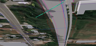
Show an intersection concept design with one road going under another and a possible park in the middle:


Check out these sweet pavement dips in this design:

We live in a 3D world, but we are used to looking at 2D maps. The switch can be daunting, but well worth it. Bring context to your maps by making them 3D.
The conversion process can take a long time, but the results are incredible.
The first time I was tasked with converting something to 3D, it was daunting. Nobody had done it before. There wasn't any documentation online about how to do so. Tech support was no help.
First, I started with LiDar points, and pulled out trees and buildings. I spent 2 weeks learning how to change the roof types and directions, the tree heights and canopy spreads. I felt like I was building a video game (does anyone remember Half Life?).
I finally got it to work. And I was proud of figuring it all out.
A random engineer came to my desk to ask for a map. He saw my screen and asked "What is that?" I told him all about it. How long it took and how difficult it was. And that I had finally figured it all out. He responded, "Who in the world would want that? Nobody will want that. What a waste of time." He threw his hands in the air and walked away before I could respond.
Awesome.
That afternoon was a public meeting for the project. I was given a 3D bridge design to add into this 3D scene for the public meeting 30 minutes prior. The bridge was added in, and the designers said they didn't realize it was so big.

The public meeting did not go as planned, with lots of comments from excited residents over the size of this thing in their backyards. But it was a success. It brought real-world context to a design. It started the conversation. And people loved to see where they lived, and yes that is what their house looks like, and yes they do have those trees and that shed in their yards.

So where can you start?
Show exactly how that proposed design will impact it's surrounding area.

Show exactly where those underground utilities run in relation to that road you need to widen.

Make a 3D model of your building with exact elevation and it's seating chart:

Show an intersection concept design with one road going under another and a possible park in the middle:


We live in a 3D world, but we are used to looking at 2D maps. The switch can be daunting, but well worth it. Bring context to your maps by making them 3D.